Master Plan FAQs
Falmouth Harbour would like to engage with the local community at a very early stage and have a conversation to explore what is possible over next 5-10 years. Take a look through the FAQs and information on the Future Harbour page – where there is a survey you can complete.
What is Falmouth Harbour and how is it run?
Falmouth Harbour is a Trust Port Independent Statutory Harbour operating as a Trust Port. Falmouth Harbour has no shareholders, and every surplus is reinvested back into the harbour for the long-term benefit of users, the town and the wider economy. Our responsibilities include navigational safety, environmental stewardship, leisure facilities and 24/7 pilotage for commercial shipping.
Why are you doing this now?
Falmouth Harbour want to engage with the local community at a very early stage – we are a long way from any planning or other formal consultation. We just want to have a conversation now before we go too far to look at is what is possible over next 5-10 years. Falmouth Harbour has a duty to improve and grow the harbour, so we have to consider all possible options to do that. That is all we are doing at this stage. We may determine that we can’t do anything due to factors such as consents, economics, value for money or the weight of opinion is against an idea.
This is an idea which we are exploring. We believe that this pontoon project has potential so just want an early conversation with the local community.
It seems a bit early to talk about this proposal.
We appreciate that it may feel too early to talk about this proposal, but we believe it is important to engage with the local community right from the outset. At this stage, we are simply exploring the idea and want to hear your thoughts before any formal plans are made or significant resources are committed.
This initial conversation will help us understand what is possible over the next 5-10 years and ensure that any future steps we take are guided by community input. Rest assured, no decisions have been made, and your feedback is a vital part of the process as we consider all options for the future of Falmouth Harbour.
Why are you developing a masterplan?
The masterplan is looking to provide a long-term vision, spanning 20 to 30 years, and outlines options for sustainable harbour development and resilience. Falmouth Harbour needs to consider for example; evolving trends in commercial shipping, changing leisure requirements, the necessity to diversify Falmouth Harbour business operations, and the potential rapid expansion in offshore renewables. Additionally, the masterplan proposes initiatives to better connect people with the water, enhance waterfront connectivity, deliver high-quality employment opportunities, attract investment, and improve the overall experience for residents, businesses, and visitors.
Why is a new pontoon being proposed?
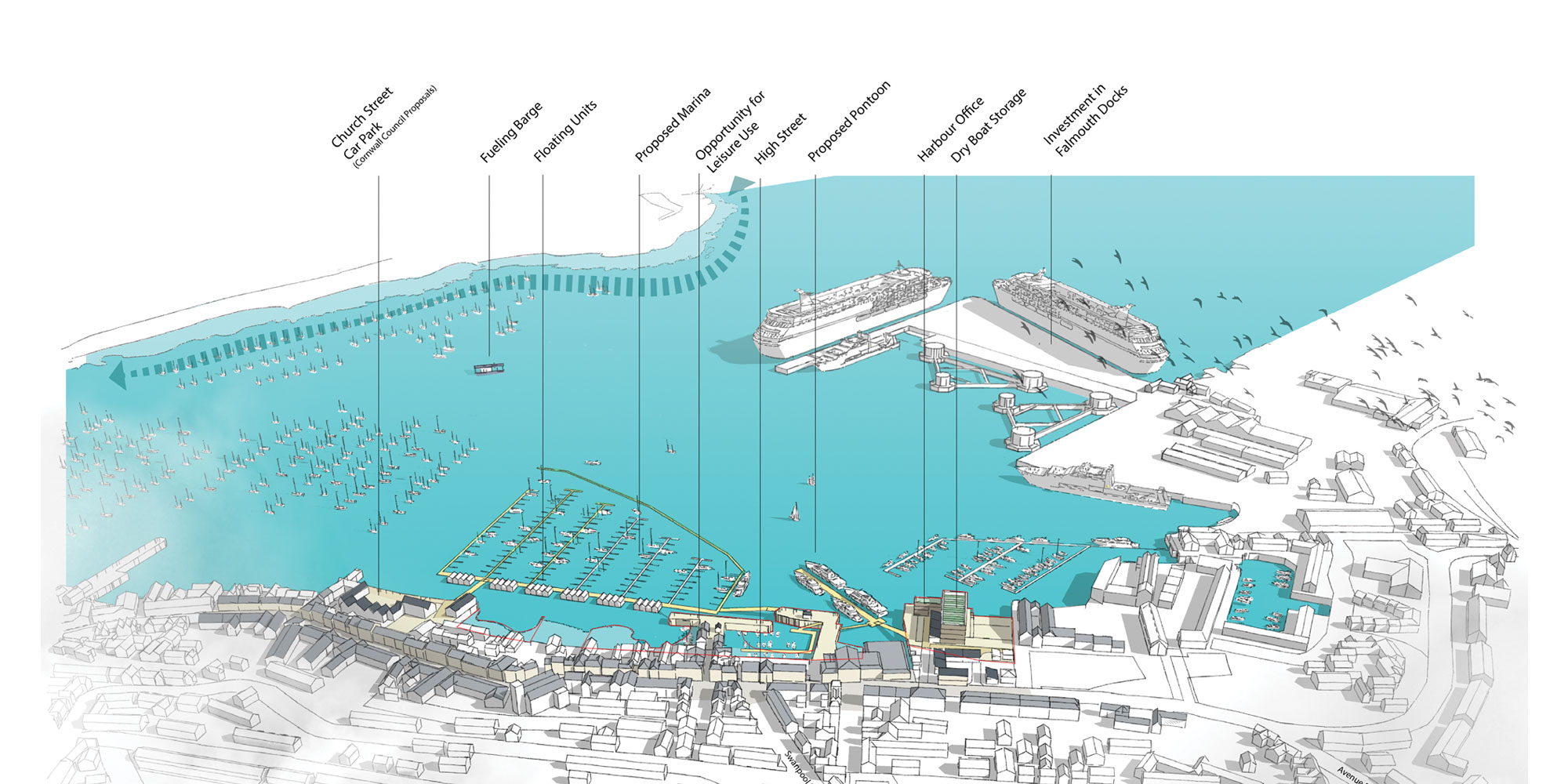
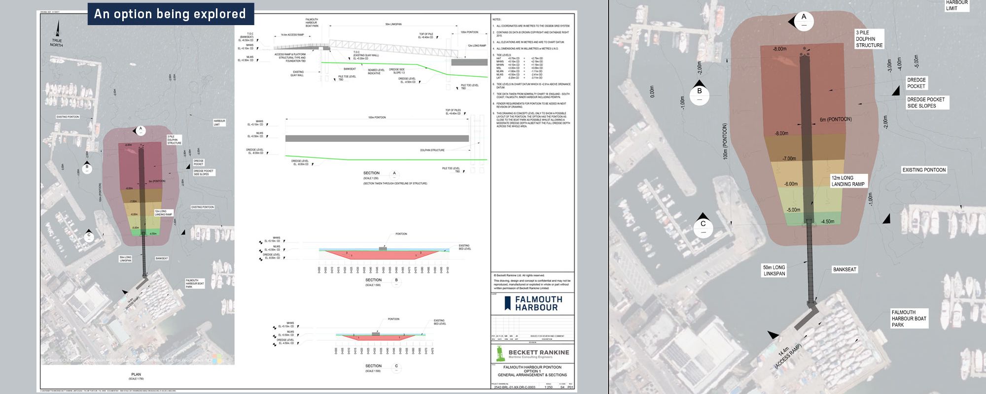
A 100-metre piled breakwater pontoon is one of the early stage masterplan projects. It could provide access for vessels of many types, from smaller offshore support vessels to superyachts, Tall Ships and event vessels. Our work to date working with local partners in industry have highlighted a shortage of berthage of this type and strong demand. Modern infrastructure is needed to keep Falmouth competitive alongside other south coast ports such as Poole and Portland, and allow us to serve a wider range of maritime activity.
What is the purpose of the new pontoon?
The new 100m piled pontoon will enhance berthing for a wide range of vessels including offshore vessels for marine renewables, Crew transfer, large maritime events such as Tall Ships and superyachts, providing a link to facilities and services directly connected into the heart of the town. It could support leisure and cultural activities, enabling Falmouth to host world-class maritime events. It could create shore-side capacity for crew transfers, repairs, refuelling and importantly accommodate future technologies such as renewable shore power and alternative fuels.
Where will the pontoon be located?
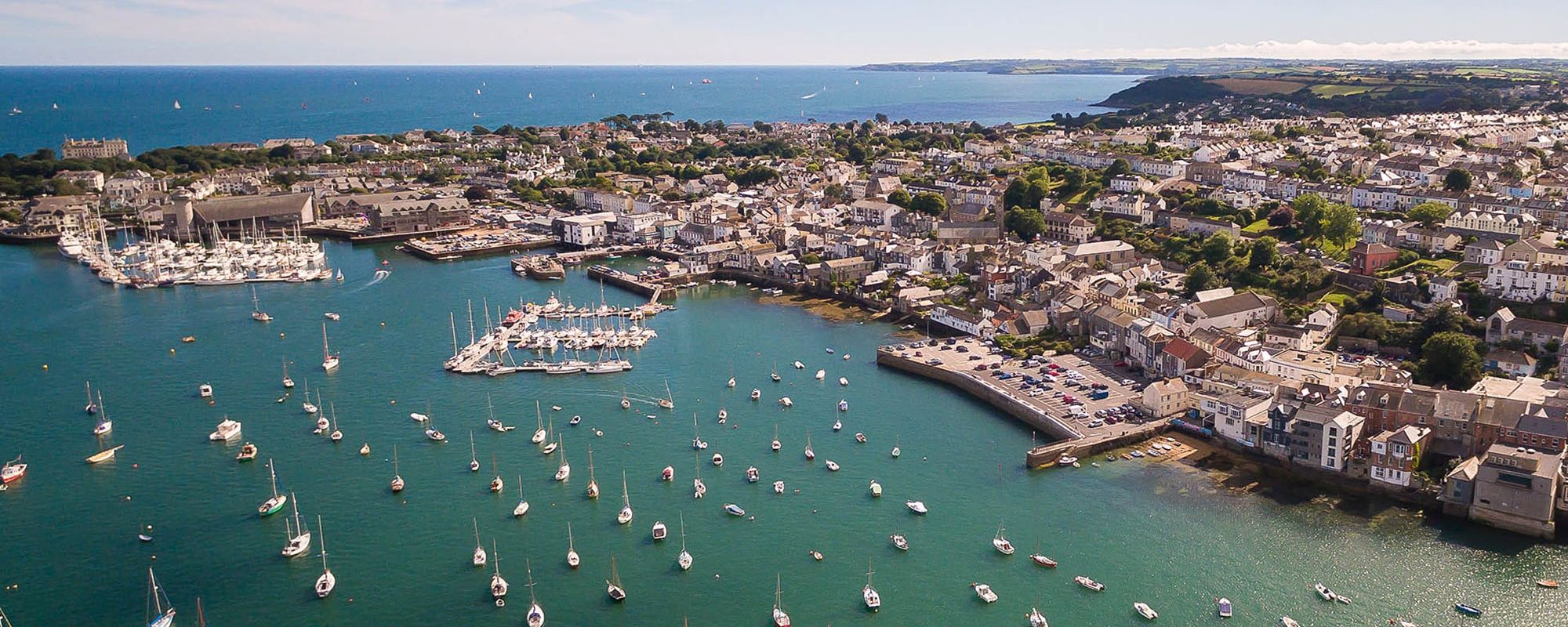
The pontoon development is proposed to be in an area of the harbour between Custom House Quay and the Boat Park at Grove Place.
Are there any sensitive habitats nearby?
The proposed development area is within or near several protected marine and coastal designations, including the Fal & Helford Special Area of Conservation (SAC) and Special Protection Areas (SPAs).
How will marine protected areas be considered?
The site is less than 200m from SAC features and within 2km of SPAs. Environmental assessments and consultations will ensure compliance with conservation requirements.
What will the environmental impacts be from this development?
We recognise that the Harbour are sensitive environments. Any proposed development would need a full Marine Management Organisation (MMO) consent, as well as likely requiring local authority planning permission. This process will include thorough environmental assessments and public consultation in due course.
Initially we are looking to complete a site investigation to assess the suitability of the area for piling and dredging this is related to sediment depth and type. Marine Management Organisation approval is needed for these investigation works. These investigations may happen in 2026/27.
If these investigations are favourable, then we may look to apply for a marine licence to install the pontoon. This would likely involve a capital dredge and the installation of some piles (steel tubes) to hold the pontoon in place and to make sure there is adequate depth at all states of the tide for the vessels that would be suitable to use the pontoon.
For each section of the works environmental impacts will be fully assessed and minimised as much as possible.
Why are you looking into putting a pontoon in this area?
We know there is an acute shortage of larger vessel berths and business and associated economic impacts are already being lost. This area was identified as a good investment in a Marine Plan completed in March 2025; due to a combination of access, services, historic building considerations, land ownership, Harbour jurisdictions, and most importantly the most direct access to deeper water with minimum dredging and impact on neighbours.
Were other locations considered?
- Insufficient depth at low water, meaning vessels could not safely berth or manoeuvre.
- Conflicts with established moorings, navigation channels or existing marine businesses.
- Limited space for safe access ramps, linkspans, utilities and crew movements.
- Higher environmental impact, particularly in more sensitive intertidal areas.
What impact will it have on other vessel movements in the area?
We have taken into account the movements of vessels in the area to hopefully make sure there is adequate space for movements to continue. Further consideration will be made as designs develop, and we will be considering vessel operators concerns at the next stages. We want to maintain all existing activity to the Boat Park and Custom House Quay and will be having deatiled meetings with those operators.
Will there be any impact on existing customer facilities?
Thorough consideration has been given to the existing facilities that may be affected, and significant efforts have been made to minimise any potential disruption or displacement. While some implications may arise, we will address and mitigate these issues during the detailed design phase.
Will there be any impacts to the local heritage quays?
We have given this matter thorough consideration and will approach it very seriously at next stages. A comprehensive heritage assessment will be conducted as part of any Marine Management Organisation licence application, ensuring all relevant factors are fully evaluated.
How can Falmouth Harbour afford to look into all of this?
This current study is part funded by the UK Government through the UK Shared Prosperity Fund, allocated through Cornwall Council’s Town Regeneration and Investment Programme (TRIP), which is part of the Cornwall and Isles of Scilly Good Growth Programme. We have allocated match funding of £40,000 from reserves towards this work which have already financed site investigations to establish the life of the boat park walls.
What design considerations are being taken into account?
- Preserving and, where feasible, enhancing existing stakeholder utilisation of the area.
- Design considerations for pontoon footprint and access linkspan.
- Land and seabed ownership constraints
- Accommodation of anticipated vessel sizes (up to 100m vessels).
- Limitations imposed by current facilities and requirements for vessel manoeuvring.
- Assessment of environmental loads, including waves, wind, and currents.
- Evaluation of stability, berthing, and fendering systems.
- Provision of essential services such as electricity, fuel, and water.
Will dredging be required?
Yes, capital dredging is required to reach depths of -6m to -8m Chart Datum (MLW). Marine borehole investigations and geophysical surveys will be conducted to assess rock levels and determine suitable dredging slopes. If dredging proves unfeasible, delivery of the pontoon in its current proposed configuration may not be possible.
What licenses are needed for dredging?
- Drawing package (plans and sections).
- Method statement.
- Risk assessments (construction and environmental).
- Water Framework Directive assessment. Additional studies may include sediment testing, hydrodynamics, and environmental assessments.
What are the next steps in the project?
- Complete conceptual design to confirm dredging and piling requirements.
- Engage with MMO for pre-application discussions.
- Draft sampling plan to enable site investigations.
- Submit MMO application to complete Site Investigation works.
- Completed Site Investigation works.
- Assess feasibility based on Site Investigation outcomes.
- Continue open engagement with harbour users and the community so feedback helps shape the project.
- Prepare and submit dredging application if feasible.
What is the expected design life of the pontoon?
The pontoon and associated structures are designed for a 50-year lifespan.
What is the development shown on the boat park area?
A “Dry Stack” storage system offers space-efficient storage for 4-8m vessels ashore, along with plans for a small Harbour Office, potential training centre, marine workspace, and amenities. Any study would consider repurposing existing land assets to support Falmouth Harbour’s mission. These ideas remain very preliminary and have not been developed or formally reviewed. We intend maintaining full access to the slipway as currently and the continued provision of boat storage to maintain accessibility for all.
When could this happen?
This is considered to be the first phase of our 20 year development plan. The project is at a very early stage, and no construction timeline has been set. There are several statutory and technical steps that must come first, each with its own process and consultation requirements. Even in a best-case scenario, the project would take several years of assessment, design and regulatory approval before construction could begin. Community input will continue throughout, and every stage will be shaped by environmental evidence and feedback.
A realistic sequence could look like this:
Exploration Licence Application – Q2 2026 apply to the Marine Management Organisation (MMO) for an exploration licence. This does not give consent to build anything; it simply allows site investigations such as sediment sampling and geotechnical surveys. Approval timelines vary, but this stage alone can take several months.
Site Investigations – Late 2026/27 – If the exploration licence is granted, we can begin investigations to understand the seabed, depth profile and engineering constraints. These results will determine whether the pontoon is even feasible in technical, environmental and commercial terms. This work typically runs for a number of months.
Detailed Design & Environmental Assessment – 2027- 2028 – If feasibility is confirmed, the next step would be detailed design and a full Environmental Impact Assessment (EIA) as part of a Marine Licence application. This is a major process that includes specialist studies, public consultation and close engagement with regulators. It can take 12–18 months or longer depending on the complexity. Only after the MMO completes the full marine licensing process could permission to construct be considered.
Construction (if approved) – 2029 onwards – If planning and marine consents are granted, construction would follow. Delivery of a structure of this scale is likely to take at least a year, depending on staging, weather and environmental windows.